Forecasters warned this spring that the 2024 Atlantic hurricane season could be particularly dangerous because of the potent combination of warm sea-surface temperatures and a looming La Niña climate pattern that would favor tropical storm formation. But as the typical peak of the season arrives in early September, the basin has been eerily quiet. The most recent named storm, Ernesto, dissipated around August 21. So were the dire hurricane forecasts wrong? Where are all the storms?
In short, the answers are “no” and “it’s complicated.”
Experts say that despite the current lull, this season has already been strong—and could still become even more active. So far this year the Atlantic has seen five named storms: two tropical storms, two hurricanes and one major hurricane. The major hurricane, Beryl, reached Category 5 status earlier than any previous storm in the Atlantic. “We definitely got started with an extremely active season,” says Brian McNoldy, a hurricane researcher at the University of Miami.
On supporting science journalism
If you’re enjoying this article, consider supporting our award-winning journalism by subscribing. By purchasing a subscription you are helping to ensure the future of impactful stories about the discoveries and ideas shaping our world today.
And considering the number and strength of individual storms is only one way to evaluate a hurricane season. Another important tool for understanding tropical activity is a measurement called accumulated cyclone energy, or ACE, which represents the overall activity of tropical storms and hurricanes in the Atlantic. To calculate ACE, every six hours, scientists tally the wind speeds of every storm that is strong enough to have a name—those with peak sustained winds of at least 39 miles per hour. Each storm’s wind speed is squared, and then the values are added together. This is done four times a day all season long.
This year’s ACE score is still 50 percent above the average season-to-date value from 1991 to 2020, according to the National Oceanic and Atmospheric Administration—hardly a quiet year. According to McNoldy, much of the power of the season to date came from Hurricane Beryl, which was both powerful and long-lasting. Ernesto also contributed significantly to the current ACE score.
Moreover the Atlantic hurricane season stretches until November 30—leaving plenty of time for activity to ramp up again and erase the calm of recent weeks. “Just because we’re kind of stumped about the last couple weeks and maybe this week, it’s definitely too early to say anything about the whole hurricane season,” McNoldy says.
But scientists are indeed “kind of stumped” about the current situation. The same factors that had them worried ahead of this hurricane season are still in play, McNoldy says. Sea-surface temperatures across the eastern Atlantic, the Caribbean and the Gulf of Mexico all remain nearly two degrees Fahrenheit (1 degree Celsius) above average, offering ample warm water for tropical storms to feed on. And as predicted, the El Niño climate pattern that tends to suppress hurricanes in the Atlantic has been shifting toward La Niña conditions, which feature lower rates of wind shear that break tropical storms apart.
Thus, the stage remains set for serious storms to grow in the Atlantic—they simply don’t seem to be doing so. The trends are too preliminary for anything more than hypotheses, but to understand the situation, scientists are turning their eyes to Africa, where the seed disturbances of inclement weather that become hurricanes are birthed. Here, two phenomena may be playing a role in the current hurricane lull.
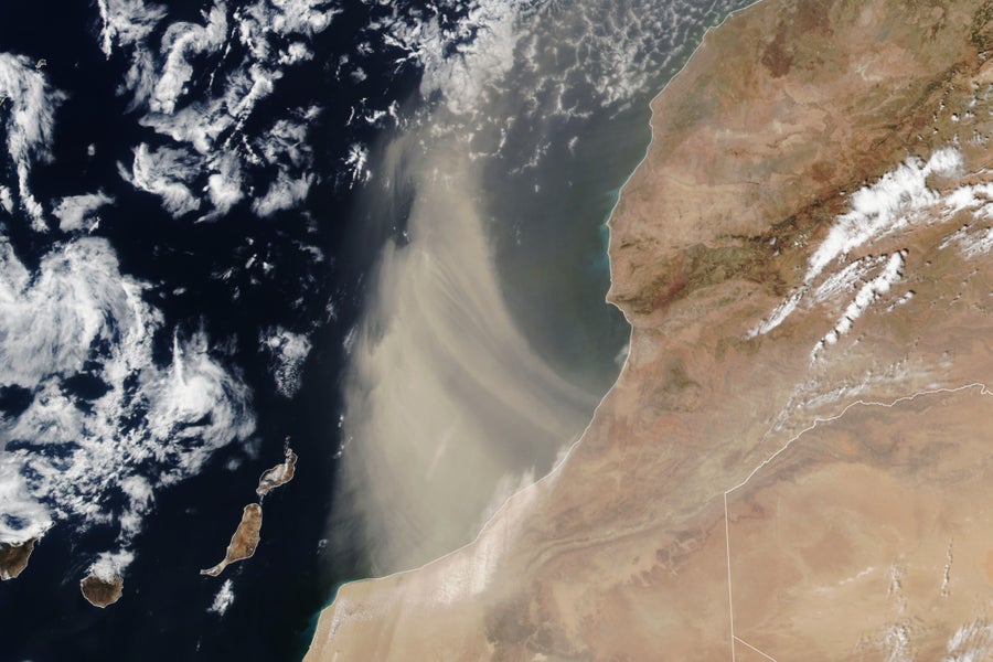
Dense bands of Saharan dust streamed offshore from southern Morocco over the Atlantic Ocean on August 24, 2024.
NASA Earth Observatory image by Lauren Dauphin, using VIIRS data from NASA EOSDIS LANCE, GIBS/Worldview, and the Suomi National Polar-orbiting Partnership
One is the plume of dust that rises off the Sahara Desert and is carried by winds across the Atlantic. It makes sense that this dust could interfere with hurricanes because it travels along a similar route to brewing tropical storms—and because dust is dry, and storms feed on moisture. And some research has shown interactions between Saharan dust and tropical storms, although the relationship is quite complicated, says Yuan Wang, an atmospheric scientist at Stanford University and co-author of one such study, published earlier this year.
That work showed that Saharan dust can reduce the amount of precipitation in a hurricane, yet Wang suspects it could also reduce the formation of hurricanes in the first place. “I think it’s very possible the dust plays a role in this year’s drought hurricane season,” he says, although that explanation remains speculative. “I think we still need very rigorous scientific research to do some attribution analysis.”
A second factor of interest is that the West African monsoon has been unusually wet this year, says Kelly Núñez Ocasio, an atmospheric scientist at Texas A&M University. The West African monsoon is a seasonal wind pattern that carries rain from the Atlantic Ocean over into West Africa between June and September. Núñez Ocasio has studied how the monsoon affects the seeds of hurricanes. And in a paper published earlier this year, she and her colleagues modeled how the atmosphere responds to additional moisture.
Those simulations suggest that in wetter conditions, the West African monsoon pushes a band of air called the African easterly jet northward. Under normal conditions, that jet produces atmospheric disturbances called African easterly waves, which can become hurricanes once they reach the Atlantic. But when the jet is in a more northern position, it seems to inhibit the development and survival of these waves, Núñez Ocasio and her colleagues found, making hurricanes less likely despite all the moisture.
She says those conditions in Africa may continue to dampen this year’s Atlantic hurricane season. “I don’t see it changing so dramatically that we’re going to see, all of a sudden, a fast spin-up of multiple hurricanes before October,” Núñez Ocasio says. “It’s just too stable, and when conditions are stable, it’s hard to make it unstable. It’s going to take quite a bit.”
Núñez Ocasio would like forecasters to start looking beyond the Atlantic Ocean to assess hurricane-forming conditions. But for the general public, she adds that it’s still important for people in the Caribbean and the southern and eastern U.S. to stay on their guard because even unnamed storm systems can cause serious flooding and other damage.
Forecasters agree. “We remain concerned about the entire Atlantic basin in terms of development risks, as it only takes one tropical storm or hurricane to cause a potential catastrophe,” says Dan Harnos, a meteorologist at NOAA’s Climate Prediction Center.
Forecasters also caution that the season could see major storms despite the current lull in Atlantic activity. “Conditions still appear very favorable for above normal activity during the remainder of the hurricane season,” says Jamie Rhome, deputy director of NOAA’s National Hurricane Center. And late-season storms can be brutal: for example, late October 2012 spawned Hurricane Sandy, which affected parts of the Caribbean before becoming racing toward the and U.S. East Coast and devastating New Jersey and New York.
Swings in hurricane activity levels aren’t unusual, McNoldy emphasizes. “You can have weeks of on and then weeks of off, and that’s pretty normal,” he says. He points to 2022, which saw no named storms in the Atlantic between July 2 and September 1—two full months of eerie quiet. But September saw both Fiona and Ian become major hurricanes, with the latter causing severe flooding in Florida and coastal North Carolina.
“I think it’s a little too soon to count this season out,” McNoldy says. “Even if you have this long period of quiet, there’s still a lot of hurricane season ahead.”


