

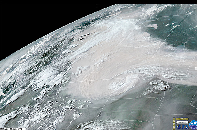
A “smokestorm” swirls over North America, as seen by the GOES-16 satellite on May 20, 2023. (Credit: Screenshot of animation RAMMB/CIRA Slider animation)
On May 20, 2023, the GOES-16 satellite acquired astonishing imagery of what one climate scientist described as a “smokestorm.”
It happened as massive amounts of smoke billowing up from wildfires blazing in the western Canadian province of Alberta got sucked into a low-pressure weather system whirling counterclockwise near the border of Canada and the United States. You can see it in the screenshot above, and in this animation:
So far this year, some 500 wildfires have scorched more than 3,600 square miles of Alberta. That land area is equivalent to more than ten times the size of the City of New York.
A cause for most of the blazes has not been determined. But as of May 20, 11 had been confirmed as caused by lightning, and 17 human-caused.
Temperatures in Alberta have been running far above normal, and it has been quite windy as well — conditions that have helped the fires spread. For example, on May 4, temperatures in Fort McMurray in the northern part of the province soared to a record high 90 degrees F, shattering the previous record by 20 degrees. The average high for that day is just 55 degrees F. Throughout the month, winds have frequently gusted above 25 miles per hour, and sometimes well above 30.
Wildfire and Climate Change
Increasing temperature, aridity and drought have lengthened fire seasons across one quarter of the world’s vegetated areas since 1979. Evidence also shows “that human-caused climate change has driven increases in the area burned by wildfire in the forests of western North America, according to the latest report of the Intergovernmental Panel on Climate Change.
“Across this region, the higher temperatures of human-caused climate change doubled [the] burned area from 1984 to 2015, compared with what would have burned without climate change,” according to the IPCC report. The additional area burned is greater than the land area of Switzerland. During one particularly bad year in British Columbia, drought and high temperatures contributed to fires that burned seven to eleven times the area that would have burned without climate change.