


After pummeling Guam on Wednesday, Super Typhoon Mawar has strengthened into one of the most powerful tropical cyclones ever recorded in the month of May.
For a time on Friday, May 26, Mawar howled with maximum sustained winds of 185 miles per hour. That has made it 2023’s strongest storm so far. It’s also stronger than any of 2022’s tropical cyclones. With gusts approaching 210 miles per hour, Mawar has pushed up waves nearly 65 feet tall, according to the Joint Typhoon Warning Center.
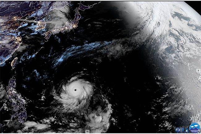
A stunning view of Super Typhoon Mawar churning over the western Pacific as a Category 5 storm on May 26, 2023, as seen by the Himawari-9 satellite. (Credit: CIRA/CSU & JMA/JAXA)
Mawar is our planet’s fifth Category 5 storm of 2023, just shy of the 1990-2022 average of 5.3 for an entire calendar year.
“This is an unusually large number of these most violent of tropical cyclones for so early in the year,” says meteorologist Jeff Masters. “With the most active portion of the Northern Hemisphere tropical cyclone season yet to come, 2023 may have a chance of challenging the record of 12 Cat 5s in a year, set in 1997.”
Super Typhoon Mawar’s eye, as seen on May 24, 2023 by the Himawari-9 satellite. (Credit: CIRA)
Satellites have been providing jaw-dropping views of Mawar. The closeup animation of Mawar’s eye above is one example. Acquired by the Himawari-9 satellite on May 24, it reveals a phenomenon known as the “stadium effect,” which is sometimes seen in strong tropical cyclones. It is a feature of the eyewall — the vertical wall of intense thunderstorms that surround the relatively calm eye, which is typically about 25 to 40 miles in diameter.
With the stadium effect, the towering clouds of the eyewall curve outward from the surface with height. The appearance is akin to a sports stadium seen from above.
Features known as “mesovortices” are also visible. These mini-cyclones are often found within the eyes of intense tropical cyclones. Wind speeds within them can be up to 10 percent higher than in the eyewall.
Climate Change Connections
Although it has been challenging for scientists to quantify the effect of a warming climate on tropical cyclones like Mawar, a few trends have become increasingly clear.
The global proportion of major tropical cyclones — Category 3, 4 and 5 storms — has likely risen over the past 40 years, according to the most recent report of the Intergovernmental Panel on Climate Change. (These storms have sustained winds of 111 mph or more.) So has the frequency of rapidly intensifying storms.
There is also “high confidence” that human-caused climate change has contributed to an increase in intense rainfall from tropical cyclones, according to the IPCC. In part, that’s because a warmer atmosphere can hold more moisture.
Moreover, the IPCC notes that the pace at which tropical cyclones move across the surface has likely slowed, with evidence showing that anthropogenic climate change has made some contribution to this effect, at least over the United States. This allows storms to linger longer over any given area, leading to greater rainfall and the potential for catastrophic flooding.
The Forecast For Mawar
After reaching sustained winds of 185 mph on Friday, May 26, Mawar began to weaken as it underwent a phenomenon known as an eyewall replacement cycle. When this happens, a new eye develops around the old eye.
After the eyewall replacement is complete, the storm is expected to re-intensify slightly as it churns over warm seas, according to the Joint Typhoon Warning Center. In about three days, as Mawar approaches the vicinity of the Philippine Islands, it will be traveling over cooler seas and is forecast to weaken.
The storm could threaten the island nation, and then possibly Taiwan. But at this point, its track is uncertain. Time will tell.